


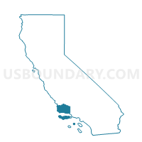
Voting District 20201, Santa Barbara County, California
About
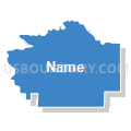
Outline

Summary
| Unique Area Identifier | 543144 |
| Name | Voting District 20201 |
| County | Santa Barbara County |
| State | California |
| Area (square miles) | 10.40 |
| Land Area (square miles) | 10.40 |
| Water Area (square miles) | 0.00 |
| % of Land Area | 99.99 |
| % of Water Area | 0.01 |
| Latitude of the Internal Point | 34.50445250 |
| Longtitude of the Internal Point | -119.80170880 |
Maps


Graphs
Select a template below for downloading or customizing gragh for Voting District 20201, Santa Barbara County, California


Neighbors
Neighoring Voting District (by Name) Neighboring Voting District on the Map
- Voting District 20206, Santa Barbara County, CA
- Voting District 20231, Santa Barbara County, CA
- Voting District 20401, Santa Barbara County, CA
- Voting District 20551, Santa Barbara County, CA
- Voting District 30066, Santa Barbara County, CA
- Voting District 30196, Santa Barbara County, CA
Top 10 Neighboring County Subdivision (by Population) Neighboring County Subdivision on the Map
- Santa Barbara CCD, Santa Barbara County, CA (184,449)
- Solvang-Santa Ynez CCD, Santa Barbara County, CA (22,670)
Top 10 Neighboring Elementary School District (by Population) Neighboring Elementary School District on the Map
- Goleta Union Elementary School District, CA (76,041)
- Hope Elementary School District, CA (15,459)
- College Elementary School District, CA (5,818)
Top 10 Neighboring Secondary School District (by Population) Neighboring Secondary School District on the Map
- Santa Barbara High School District, CA (184,132)
- Santa Ynez Valley Union High School District, CA (21,027)
Top 10 Neighboring State Legislative District Lower Chamber (by Population) Neighboring State Legislative District Lower Chamber on the Map
Top 10 Neighboring State Legislative District Upper Chamber (by Population) Neighboring State Legislative District Upper Chamber on the Map
Top 10 Neighboring 111th Congressional District (by Population) Neighboring 111th Congressional District on the Map
Top 10 Neighboring Census Tract (by Population) Neighboring Census Tract on the Map
- Census Tract 19.06, Santa Barbara County, CA (5,870)
- Census Tract 29.07, Santa Barbara County, CA (4,190)
- Census Tract 1.03, Santa Barbara County, CA (3,196)